
Soil salinization risk assessments under future climate conditions: The case of central Huai Luang River Basin, Northeast, Thailand
Article Sidebar
Main Article Content
Abstract
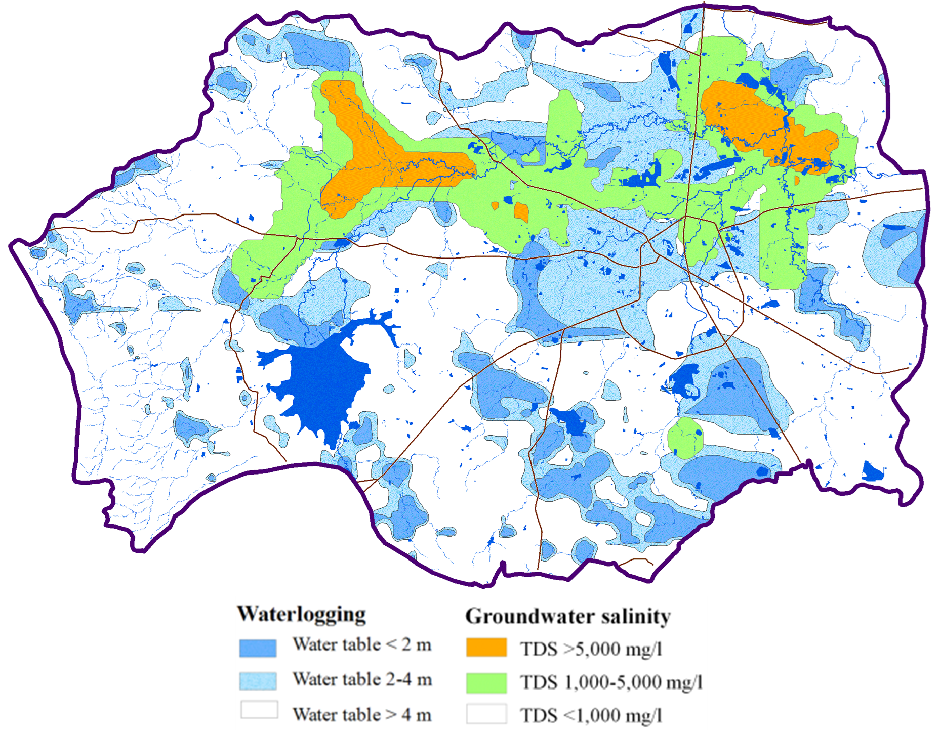
Salt-affected soil is one of the main problems decreasing the productivity of agriculture in Northeast Thailand. The Central Huai Luang Basin is the important rice producing areas of Udon Thani Province that is affected by saline soil. Regional and local groundwater flow systems are the major mechanisms responsible for spreading saline groundwater, waterlogging and the consequences of saline soils in this basin. Climate change may have an impact on groundwater recharge, on water table depth and the consequences of waterlogging, and on the distribution of soil salinity in this basin. A simulation model, in combination with groundwater models and the Geographical Information System (GISs), could be used to evaluate the risk of salinization. Five data, including soil salinity, soil group, irrigation area, groundwater salinity and waterlogging were used to input criteria data into a soil salinity risk model, which then calibrates the soil salinity simulation using field data. Three future climate conditions of RCPs from the CanESM2 models were downscaled to investigate the impact of future climate conditions on soil salinity risk. The impact of climate change was investigated by using a set of groundwater numerical models, namely HELP3 and SEAWAT, to estimate groundwater recharge and flow, and salt transport of the groundwater simulation, respectively. The results revealed that within the next 30 years (2045) the future average annual temperature and precipitation are projected to increase by 1.79oC and 7.56% from current figures, respectively. The results showed that the impact of climate change on soil salinity distribution is projected to increase in every climate condition. By 2045 the salinity risk area will increase by about 216.90 km2, or 23.62% from the current salt-affected area. The projected soil salinity assessment presented here is useful for targeting critical areas that may require special management for preventing or controlling soil salinization.
Article Details

This work is licensed under a Creative Commons Attribution-NonCommercial-NoDerivatives 4.0 International License.
References
Martinez-Beltran J, Manzur CL. Overview of salinity problems in the world and FAO. 2005.
Greene R, Timms W, Rengasamy P, Arshad M, Cresswell R. Soil and Aquifer Salinization: Toward an Integrated Approach for Salinity Management of Groundwater. In: Jakeman A.J., Barreteau O, Hunt R.J., Rinaudo JD, Ross A, editors. Integrated Groundwater Management. Springer, Cham. 2016:377-412. https://doi.org/10.1007/978-3-319-23576-9_15.
Asfaw E, Suryabhagavan, Argaw M. Soil salinity modeling and mapping using remote sensing and GIS: The case of Wonji sugar cane irrigation farm, Ethiopia. Journal of the Saudi Society of Agricultural Sciences. 2018;17(3):250-258. https://doi.org/10.1016/j.jssas.2016.05.003.
De Paz J.M., Visconti F, Zapata R, Sanchez J. Integration of two simple models in a geographical information system to evaluate salinization risk in irrigated land of the Valencian Community, Spain. Soil Use and Management. 2004;20:333-342. https://doi.org/10.1111/j.1475-2743.2004.tb00378.x.
Arunin S. Strategies for Utilizing Salt-affected Lands in Thailand. Proceedings of The Int. Symp. On Strategies for Utilizing Salt-affected Lands, Bangkok, Thailand. 1992;259-68.
Arunin S. Characteristic and management of salt-affected soils in the northeast of Thailand. 1984.
Srisuk K. Genetic characteristics of the groundwater regime in the Khon Kaen drainage basin, Northeast Thailand. Doctoral Dissertation, University of Alberta, Canada. 1994.
Allan, M.J. An assessment of secondary dryland salinity in Victoria. CLPR Technical Report: CNR; Report No.14. 1994.
Saraphirom P, Wirojanagud W, Srisuk K. Impact of climate change on waterlogging and salinity distributions in Huai Khamrian subwatershed, NE Thailand. Environ Earth Sci. 2013;70(2):887-900. https://doi.org/10.1007/s12665-012-2178-x.
Chinvanno S, Laung-Aram V, Sangmanee C, Thanakitmetavut J. Future climate projection for Thailand and Mainland Southeast Asia using PRECIS and ECHAM4 climate models. Technical report 18. Southeast Asia START Regional Center; 2009.
Manomaiphiboon K, Octaviani M, Torsri K. Regional climate modeling using RegCM3 for Thailand: Past and ongoing activities. The first China-Thailand Joint Seminar on Climate Change; 2009 Mar 23-24; Bangkok, Thailand Research Fund, Bangkok, Thailand. 2009.
Santisirisomboon J. Statistical Downscaling of GFDL-R30 in the area of Thailand. The first China-Thailand Joint Seminar on Climate Change; 2009 Mar 23-24; Bangkok, Thailand Research Fund, Bangkok, Thailand. 2009.
TRF. IPCC &TARC Report: State of Knowledge on the World and Thailand's Climate Change. T-GLOUB, Thailand Research Fund, Bangkok, Thailand. 2011.
Chinvanno S. Adaptation to climate change and strategic for developing, Projection for building capacity for Adaptation to climate change: case study of in Huai Luang River Basin Thailand. Southeast Asia START Regional Center. 2014.
HAII. The context of climate change in Thailand. Hydro and Agro Informatics Institute: Ministry of Science and Technology, Thailand. 2016.
Chaowiwat W, Danusatianpong P, Sarinnapakorn K, Boonya S. Extreme Climate Prediction for Water Management Community Network under Changing Climate. The 22nd National Convention on Civil Engineering; 18-20 July 2017; Nakhon Ratchasima, Thailand. 2017.
NSO. Gross Provincial Product in Thailand. National Statistical Office. Bangkok, Thailand. 2016.
TMD. Weather data of Udon Thani Province. Thai Meteorological Department, Ministry of Information and Communication Technology, Bangkok. 2015.
RID. Rainfall and steam flow data of Udon Thani Province. Royal Irrigation Department, Ministry of Agriculture and Cooperatives, Udon Thani Province, Thailand. 2015.
LDD. Land use map of Northeast Thailand 1:100,000. Land Development Department. Ministry of Agriculture and Cooperatives, Bangkok. 2013.
LDD. The marvelous of soil: soil group for economic crops. Bangkok, Thailand: Land Development Department. Ministry of Agriculture and Cooperatives: Bangkok. 2005.
Im-Erb R, Sukchan S. Salt -affected soils in Thailand: Assessment and monitoring of salinization and status of biosaline agriculture. Reports of expert consultation held in Dubai, United Arab Emirates, 26-29 Nov 2007. World Soil Resources reports no. 104. FAO, Rome, Italy. 2009:19-20.
LDD. Saline soil map of Northeast Thailand scale 1:100,000. Land Development Department, Ministry of Agriculture and Cooperatives, Bangkok. 2006.
Phontusang P, Kattawatin R, Pannangpetch K. Lerdsuwansri, R., Kingpaiboon, S., Wongpichet, K. Field-scale Spatial Variability of Electrical Conductivity of the Inland, Salt-affected Soils of Northeast Thailand. Walailak J Sci & Tech. 2018;15(5): 341-355. https://doi.org/10.48048/wjst.2018.3474.
Wichaidit P. The manual of northeastern Thailand saline map. Department of Land Development, Bangkok. 1997:174-76.
FAO. Prognosis of salinity and alkalinity. FAO Soil Bulletin 31. Food and Agriculture Orginasation of the United Nations, Rome, Italy. 1976.
LDD. Soil Series Map scale 1:25,000. Bangkok, Thailand: Land Development Department. Ministry of Agriculture and Cooperatives: Bangkok. 2007
Yuvaniyama A. Manual of saline soils management and reclamation. Technical paper of research and development of salt-affected areas group. Land Development Department, Bangkok. 2004.
Dobermann A, Fairhurst T. Salinity in rice nutrient disorders & nutrient management. Potash & Phosphate Institute of Canada and International Rice Research Institute. 2000:139-44.
Clermont-Dauphin C, Suwannang N, Grünberger O, Hammecker C, Maeght JL. Yield of rice under water and soil salinity risks in farmers' fields in northeast Thailand. Field Crops Res. 2010;118(3):289-96. https://doi.org/10.1016/j.fcr.2010.06.009.
DMR. Hydrogeological map of Thailand 1:250,000. Department of Mineral Resources, Ministry of Natural Resources and Environment: Bangkok. 2009.
Suwanich P. Potash and Rock salt in Thailand. Nonmetallic Minerals Bulletin No.2. Economic Geology Division, Department of Mineral Resources, Bangkok. 1986.
Cotanont T, The application of environmental isotopes and Fractured analysis for sustaninable groundwater development: A case study of fractured sandstone and siltstone aquifers, Udon Thani Province. Doctoral Dissertation, Khon Kaen University. 2014.
DeutschWJ, Groundwater chemistry-fundamentals and applications to contamination. Boca Raton: Lewis Publishers, New York. 1997:221.
IPCC. The physical science basic-summary for policymakers. Contribution of WGI to the Fifth Assessment Report of the Intergovernmental Panel on Climate Change. 2013.
Pratoomchai W, Kazama S, Hanasaki N, Ekkawatpanit C, Komori D. A projection of groundwater resources in the Upper Chao Phraya River basin in Thailand. Hydrol Res Lett. 2014;8(1):20-6. https://doi.org/10.3178/hrl.8.20.
Saraphirom P, Wirojanagud W, Srisuk K. Potential Impact of climate change on area affected by waterlogging and saline groundwater and ecohydrology management in northeast Thailand. Environment Asia. 2013b;6(1):19-28. https://doi.org/10.14456/ea.2013.4.
Shrestha S, Bach TV, Pandey VP. Climate change impacts on groundwater resources in Mekong Delta under representative concentration pathways (RCPs) scenarios. Environ Sci Policy. 2016;61:1-13. https://doi.org/10.1016/j.envsci.2016.03.010.
Moeck C, Brunner P, Hunkeler D. The influence of model structure on groundwater recharge rates in climate-change impact studies. Hydrogeol J [Internet]. 2016;24(5):1171-84. https://doi.org/10.1007/s10040-016-1367-1.
Langevin CD, Thorne DT. Jr, Dausman AM, Sukop MC, Guo W. SEAWAT Version 4: a computer program for simulation of multi-species solute and heat transport. US Geological Survey Techniques and Methods Book 6, chapter A22. 2008. https://doi.org/10.3133/tm6A22.
Schroeder, PR, Dozier, TS, Zappi, PA, McEnroe, BM, Sjostrom, JW, & Peyton, RL. The Hydrologic Evaluation of Landfill Performance (HELP) Model: Engineering Documentation for Version 3, EPA/600/R-94/168b, September 1994, U.S. Environmental Protection Agency Office of Research and Development, Washington, DC.
Jyrkama MI, Sykes JF, Normani SD. Recharge estimation for transient ground water modeling. Ground Water. 2002;40(6):638-48. https://doi.org/10.1111/j.1745-6584.2002.tb02550.x.
Jyrkama MI, Sykes JF. The impact of climate change on spatially varying groundwater recharge in the grand river watershed (Ontario). J Hydrol (Amst). 2007;338(3-4):237-50. https://doi.org/10.1016/j.jhydrol.2007.02.036.
Scibek J, Allen D. Comparing modelled responses of two high-permeability, unconfined aquifers to predicted climate change. Glob Planet Change. 2006;50(1-2):50-62. https://doi.org/10.1016/j.gloplacha.2005.10.002.
Scibek J, Allen DM, Cannon AJ, Whitfield PH. Groundwater-surface water interaction under scenarios of climate change using a high-resolution transient groundwater model. J Hydrol (Amst). 2007;333(2-4):165-81. https://doi.org/10.1016/j.jhydrol.2006.08.005.
Pholkern K, Saraphirom P, Srisuk K. Potential Impacts of Climate Change on Groundwater Resources in the Central Huai Luang Basin, Northeast Thailand. Science of the Total Environment Journal. 2018;633:1518-1535. https://doi.org/10.1016/j.scitotenv.2018.03.300.
Chylek P, Li J, Dubey MK, Wang M, Lesins G. Observed and model simulated 20th century Arctic temperature variability: Canadian Earth System Model CanESM2. Chem. Phys. Discuss. 2011. https://doi.org/10.5194/acpd-11-22893-2011.
van Vuuren DP, Edmonds J, Kainuma M, Riahi K, Thomson A, Hibbard K, et al. The representative concentration pathways: an overview. Clim Change. 2011;109(1-2):5-31. https://doi.org/10.1007/s10584-011-0148-z.
El-Gammal MI, Ali RR, Abou Samra RM. GIS-based land degradation risk assessment of Damietta governorate, Egypt. Egypt J Basic Appl Sci. 2015;2(3):183-9. https://doi.org/10.1016/j.ejbas.2015.01.001.
Corwin DL, Sorensen M, Rhoades JD. Field-testing of models which identify soils susceptible to salinity development. Geoderma. 1989;45(1):31-64. https://doi.org/10.1016/0016-7061(89)90055-4.
Corwin DL, Rhoades JD, Vaughan PJ. GIS applications to the basin-scale assessment of soil salinity and salt-loading to the groundwater. In: Applications of GIS to the modeling of non-point source pollutants in the vadose zone, eds DL Corwin &K; 1996. https://doi.org/10.2136/sssaspecpub48.
Corwin DL, Vaughan PJ, Loague K. Modeling nonpoint source pollutants in the vadose zone with GIS. Environ Sci Technol. 1997;31(8):2157-75. https://doi.org/10.1021/es960796v.
Vaughan PJ, Simunek J, Suarez DL, Corwin DL, Rhoades JD. Unsatchemgeo: Modeling water flow and multicomponent solute transport in a GIS context. In: Corwin & K Loague, editors. Applications of GIS to the modeling of non-point source pollutants in the vadose zone DL. SSSA Special Publication No. 48. Soil Science Society of America Madison WI Ch 14; 1996. p. 235-246. https://doi.org/10.2136/sssaspecpub48.c14.
Bui E. Assessing the regional risk of salinisation over the Dalrymple Shire. Technical report 26/97. CSIRO Land and Water, P0 Box 1666,Canberra, ACT 2601, Australia. 1997.
Bui E, Keith RJ, Moran CJ, Williams J. Use of a soil survey information to assess regional salinisation risk using Geographical Information Systems. Journal Environmental Quality. 1996;25:433-439. https://doi.org/10.2134/jeq1996.00472425002500030008x.
MacMillan RA, Marciak, LC. Modeling potential salinity hazard (PSH): predicting potential salinity hazard for a range and diverse test region in Alberta, Canada. In: Proceedings of 4th International Conference on Integrating GIS and Environmental Modeling (GIS/EM4), Banff, Canada. 2000.
Utset A, Borroto M. A modeling-GIS approach for assessing irrigation effects on soil salinisation under global warming conditions. Agric Water Manag. 2001;50(1):53-63. https://doi.org/10.1016/S0378-3774(01)00090-7.
Masoudi M, Patwardhan AM, Gore SD. A new methodology for producing of risk maps of soil salinity, case study: Payab Basin, Iran. J Appl Sci Environ Manage. 2006;10(3). https://doi.org/10.4314/jasem.v10i3.17312.
Jabbar MT, Zhou J. Assessment of soil salinity risk on the agricultural area in Basrah Province, Iraq: Using remote sensing and GIS techniques. J Earth Sci. 2012;23(6):881-91. https://doi.org/10.1007/s12583-012-0299-5.
Mirlas V. Assessing soil salinity hazard in cultivated areas using MODFLOWmodel and GIS tools: a case study from the Jezre'el Valley, Israel. Agric. Water Manag. 2012;109:144-54. https://doi.org/10.1016/j.agwat.2012.03.003.
El Baroudy AA, Moghanm FS. Combined use of remote sensing and GIS for degradation risk assessment in some soils of the Northern Nile Delta, Egypt. Egypt J Remote Sens Space Sci. 2014;17(1):77-85. https://doi.org/10.1016/j.ejrs.2014.01.001.
Manuel Peragón J, Delgado A, Antonio Rodríguez Díaz J, Pérez-Latorre FJ. A GIS-based decision tool for reducing salinization risks in olive orchards. Agric Water Manag. 2016;166:33-41. https://doi.org/10.1016/j.agwat.2015.12.005.
Huang J, Prochazka MJ, Triantafilis J. Irrigation salinity hazard assessment and risk mapping in the lower Macintyre Valley, Australia. Sci Total Environ. 2016;551-552:460-73. https://doi.org/10.1016/j.scitotenv.2016.01.200.
Farajnia A, Yarahmadi J. Soil Salinity and Alkalinity Map Preparation Based on Spatial Analysis of GIS (Case Study: Tabriz Plain). Open Journal of Geology. 2017;7:778-788. https://doi.org/10.4236/ojg.2017.76052.
Bloem E, van der Zee, S.E.A.T.M., Toth T, Hagyó A. Risk assessment methods of salinity. Report 2.4. Deliverable 2.3.2.1. RAMSOIL Project (Contract 44240). 2008.
Zadeh LA. Fuzzy Sets. Information and Control. 1965;8:338-53. https://doi.org/10.1016/S0019-9958(65)90241-X.
Gottwald S. Mathematical fuzzy logic as a tool for the treatment of vague information. Inf Sci (Ny). 2005;172(1-2):41-71. https://doi.org/10.1016/j.ins.2005.02.004.
Dowling T, Roberts DW, Walker J. Predicting salinity risk without the use of a process model. In 'Proceedings of Murray-Darling basin groundwater workshop'. Toowoomba. 1997.
Buchanan S, Huang J, Triantafilis J. Salinity risk assessment using fuzzy multiple criteria evaluation. Soil Use Manag. 2017;33(2):216-32. https://doi.org/10.1111/sum.12301.
Saxena VP, Mehrotra CL, Srivastava KC. Physical characteristics of some problem soils of Uttar Pradesh. Proc. All India Symp. Soil Salinity, Kanpur. 1971:30-7.
FAO. Irrigation Water Management: Training Manual No. 1. Introduction to Irrigation. Food and Agriculture Orginasation of the United Nations, Rome, Italy. 1985.
Salcon. Salinity Management Handbook. Salinity and Contaminant Hydrology Group, Department of Natural Resources, Indooroopilly. 1997.
ANZECC. Australian and New Zealand Guidelines for Fresh and Marine Water Quality. ANZECC and ARMCANZ; 2000.
RID. The Hydrogeological Model for Management of Salt Contamination, Kong-Chi-Mun Project Area (KCM), NE Thailand. Royal Irrigation Department, Ministry of Agriculture and Cooperatives, Thailand. 2010.
Ghassemi, F, Jakeman, AJ, & Nix, HA. Salinisation of Land and Water Resources - Human Causes, Extent, Management and Case Studies. 1st Edition, University of New South Wales Press Ltd., Sydney, NSW. 1995:526.
Maianu A. Methodology for determining critical depth and critical salinity of groundwater. Publ.House of the Romanian Academy, Department of Soil Science North Dakota State University, Fargo, North Dakota; 1977:134-42.
Van Schilfgaarde J. Water management and salinity. Soils Bulletin 31. FAO, Rome. 1976.
Kovda VA, USSR nomenclature and classification of saline soils. In: V. A. Kovda, C. van der Berg, R. M. Hagan, editors. Irrigation, drainage and salinity, an international source book, Hutchinson/FAO/Unesco. 1973.
Peck AJ. Note on the role of shallow aquifer in dryland salinity. Australian Journal of Soil Research. 1978;16(2):237-240. https://doi.org/10.1071/SR9780237
Zheng X, Yang JS. Using Sample Weights in Item Response Data Analysis Under Complex Sample Designs. In: L.A. van der Ark et al, editors. Quantitative Psychology Research: Springer Proceedings in Mathematics & Statistics. 2001:167.
