
A comparison to the vegetation index of KorKor 49 rice field from orthomosaic map and video by using unmanned aerial vehicle
Article Sidebar
Main Article Content
Abstract
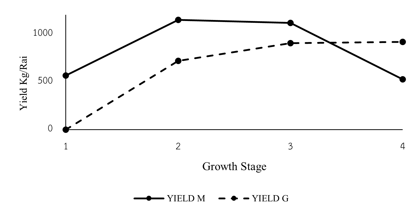
A comparison of the vegetation Index of KorKor 49 rice field from orthomosaic map and video by using unmanned aerial vehicle (UAV) aim to study a possibility of the RGB color index analysis for calculate the vegetation Index such as VARI, EXG, YIELD and Chlorophyll by using photos and videos from the UAV during the tillering, booting, flowering, and pre-harvesting stages. The RGB color index was analysis by 2 cases, Case 1 creating an orthomosaic map from photo (the photos were taken from UAV) by the process of photogrammetry using Agisoft Metashape program then analyzing the RGB color index by using QGIS program, Case 2 analysis the RGB color index by using video processing technique from MATLAB program. The result of the RGB color index from 2 case shown that it can be used to analysis the vegetation index, yield and chlorophyll which different situation. The comparison between 4 parameters shown that, VARI index the MATLAB analysis method has a trend to be consistent with rice growth than the QGIS method, EXG index the QGIS analysis method has a trend to be consistent with rice growth than the MATLAB method, chlorophyll value the MATLAB analysis method has a trend to be consistent with rice growth than the QGIS method and yield shown that, the QGIS analysis method can give precise a rice yield prediction than the MATLAB method which was error 14% in the pre-harvest stage.
Article Details

This work is licensed under a Creative Commons Attribution-NonCommercial-NoDerivatives 4.0 International License.
References
Thai PBS. News Online [Internet]. 2023 [cited 2023 Dec 20]. Available from: https://www.thaipbs.or.th/news.
Bangkok Business. News Online [Internet]. 2023 [cited 2023 Dec 20]. Available from: https://www.bangkokbiznews.com.
Khon Kaen Provincial Office. Khon Kaen Provincial development plan 2023-2027 [Internet]. 2023 [cited 2023 Dec 20]. Available from: https://www.khonkaen.go.th/khonkaen6/fileDir/vision/20230430-Plan66-70-1.pdf.
Ministry of Agriculture. Basic information of Khon Kaen Province [Internet]. 2022 [cited 2023 Dec 20]. Available from: https://www.opsmoac.go.th/khonkaen-dwl-files-451391791021.
Yamaguchi T, Tanaka Y, Imachi Y, Yamashita M, Katsura K. Feasibility of combining deep learning and RGB images obtained by unmanned aerial vehicle for leaf area index estimation in rice. Remote Sensing. 2021;13(1):1-19. https://doi.org/10.3390/rs13010084.
Muangprakon R. Monitoring rice growth and predicting rice yield by drones. Master of Engineering, Department of Civil Engineering, Mahasarakham University, Maha Sarakham, Thailand. 2021.
Chanthongpoon J, Intharat K, Khaihun S, Nisan F, Boonrasri P. Application of unmanned aerial vehicles to monitor rubber: A case study of Nam Noi Subdistrict, Hat Yai District, Songkhla Province. The 28th National Civil Engineering Conference, May 24-26, 2023, Phuket, Thailand. 2023:1-8.
Zhou X, Zheng HB, Xu XQ, He JY, Ge XK, Yao X, Cheng T, Zhu T, Cao WX, Tian YC. Predicting grain yield in rice using multi-temporal vegetation indices from UAV-based multispectral and digital imagery. Journal of Photogrammetry and Remote Sensing. 2017;130:246–55. https://doi.org/10.1016/j.isprsjprs.2017.05.003.
Thaiphanich S. Prediction of chlorophyll values in rice leaves using multiple linear regression analysis. Master of Engineering in Electrical Engineering, Rajamangala University of Technology Thanyaburi, Pathum Thani, Thailand. 2010.
Thanawong P, Aunban P. Evaluation of the consistency of high-resolution image data by drones and Sentinel-2 satellite images for monitoring rice growth. Journal of Spatial Innovation Development. 2022;3(3): 91-108.
