
Assessment of sugarcane carbon sequestration using UAV-based data
Article Sidebar
Main Article Content
Abstract
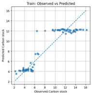
Sugarcane is a major economic crop in Thailand and has a high potential for carbon sequestration through biomass accumulation, which can contribute to the reduction of greenhouse gas emissions from the agricultural sector. However, the assessment of carbon stock in sugarcane at the field scale remains challenging due to the reliance on field-based measurements that require considerable time, labor, and resources. These limitations restrict large-scale spatial assessment and long-term monitoring. Although standard equations for estimating carbon stock from sugarcane biomass are available, their application in combination with spatial data is still limited and lacks flexibility for practical use. This study aimed to develop a Machine Learning model for estimating carbon sequestration in sugarcane using data obtained from varietal test plots, with the Khon Kaen 3 cultivar selected as a case study. Unmanned aerial vehicle (UAV) imagery was integrated with empirical equations established by the Department of Agriculture, which were used as a reference for carbon calculation. UAV data were processed to generate Digital Surface Models (DSM) and Digital Terrain Models (DTM), from which the Canopy Height Model (CHM) was derived. Structural variables of sugarcane at the clump level were extracted from the CHM and used as input variables for Machine Learning model development. The results indicated that the maximum canopy height showed a strong positive relationship with sugarcane carbon stock. The Artificial Neural Network model provided the best performance, with a coefficient of determination (R²) of approximately 0.84 and a root mean square error (RMSE) of about 1.6 tons of carbon per rai. These findings demonstrate that the proposed approach effectively links UAV-derived structural information with carbon stock estimation and extends the applicability of standard carbon calculation equations to spatial-scale assessments. The approach can support carbon management and promote sustainable agricultural development in the future.
Article Details

This work is licensed under a Creative Commons Attribution-NonCommercial-NoDerivatives 4.0 International License.
References
Office of the Cane and Sugar Board. Sugarcane and sugar situation report, production year 2024/2025. Bangkok: Office of the Cane and Sugar Board. 2025.
Department of Agriculture. Biomass and carbon estimation equations for Khon Kaen 3 Sugarcane Variety. Bangkok: Department of Agriculture. 2022.
Hairiah K, Sitompul SM, van Noordwijk M, Palm C. Methods for sampling carbon stocks above and below ground. Bogor: International Centre for Research in Agroforestry (ICRAF). 2001.
Carvalho EX, Menezes RSC, Sampaio EVSB, Simões Neto DE, Tabosa JN, Oliveira LR, Sales AT. Allometric equations to estimate sugarcane aboveground biomass. Sugar Tech. 2019;21:1039–44. https://doi.org/10.1007/s12355-019-00741-w.
Barbosa AM, Guidorizzi KA, Catuchi TA, Marques TA, Ribeiro RV, Souza GM. Biomass and bioenergy partitioning of sugarcane plants under water deficit. Acta Physiologiae Plantarum. 2015;37:142. https://doi.org/10.1007/s11738-015-1887-7.
Suwanlee SR, Pinasu D, Som-ard J, Borgogno-Mondino E, Sarvia F. Estimating sugarcane aboveground biomass and carbon stock using the combined time series of Sentinel data with machine. learning algorithms. Remote Sensing. 2024;16(5):750. https://doi.org/10.3390/rs16050750.
Bendig J, Bolten A, Bennertz S, Broscheit J, Eichfuss S, Bareth G. Estimating biomass of barley using crop surface models derived from UAV-based RGB imaging. Remote Sensing. 2014;6(11):10395–412. https://doi.org/10.3390/rs61110395.
Zhu W, Sun Z, Peng J, Huang Y, Li J, Zhang J, Yang B, Liao X. Estimating maize above-ground biomass using 3D point clouds of multi-source unmanned aerial vehicle data at multi-spatial scales. Remote Sensing. 2019;11(22):2678. https://doi.org/10.3390/rs11222678.
Pratum C, Kachenchart B, Konglum P, Phutthai T. Sugarcane yield estimation using UAV- based RGB images and allometric equations. Current Applied Science and Technology. 2024;25(3):e0259856. https://doi.org/10.55003/cast.2024.259856.
IPCC. 2006 IPCC Guidelines for National Greenhouse Gas Inventories. Volume 4: Agriculture, Forestry and Other Land Use. Eggleston HS, Buendia L, Miwa K, Ngara T, Tanabe K, editors. Institute for Global Environmental Strategies (IGES), Hayama, Japan. 2006.
Liu X, Wang R, Shi W, Wang X, Yang Y. Research on estimation model of carbon stock based on airborne LiDAR and feature screening. Sustainability. 2024;16(10):4133. https://doi.org/10.3390/su16104133.
Cheng F, Ou G, Wang M, Liu C. Remote sensing estimation of forest carbon stock based on machine learning algorithms. Forests. 2024;15(4):681. https://doi.org/10.3390/f15040681.
Nguyen TT. Applied machine learning algorithms and Landsat 8 for estimating aboveground carbon stock in evergreen broadleaf forest in Binh Phuoc Province. VNU Journal of Science: Earth and Environmental Sciences. 2022;38(4):89-104. https://doi.org/10.25073/2588-1094/vnuees.4890. https://doi.org/10.25073/2588-1094/vnuees.4890.
Ilarionova S, Tregubova P, Shukhratov I, Shadrin D, Efimov A, Burnaev E. Advancing forest carbon stocks mapping using a hierarchical approach with machine learning and satellite imagery. Scientific Reports. 2024;14: 21032. https://doi.org/10.1038/s41598-024-71133-8.
